| [1] |
Zhang Z, Hu H P, Tian F Q, et al. Groundwater dynamics under water saving irrigation and implications for sustainable water management in an oasis: Tarim River Basin of western China[J]. Hydrology and Earth System Sciences Discussions, 2014, 18(10): 3951-3967.
|
| [2] |
庞爱萍, 易雨君, 李春晖. 基于生态需水保障的农业用水安全评价--以山东省引黄灌区为例[J]. 生态学报, 2021, 41(5): 1907-1920.
|
|
[ Pang Aiping, Yi Yujun, Li Chunhui. Evaluation of agricultural water-use security with ecological water demand as a priority: A case study of the Yellow River estuary in Shandong Province[J]. Acta Ecologica Sinica, 2021, 41(5): 1907-1920. ]
|
| [3] |
Zhang Y, Zhu G F, Ma H Y, et al. Effects of ecological water conveyance on the hydrochemistry of a terminal lake in an inland river: A case study of Qingtu Lake in the Shiyang River Basin[J]. Water, 2019, 11(8): 1673, doi: 10.3390/w11081673.
doi: 10.3390/w11081673
|
| [4] |
康绍忠, 许迪. 我国现代农业节水高新技术发展战略的思考[J]. 中国农村水利水电, 2001(10): 25-29.
|
|
[ Kang Shaozhong, Xu Di. Reflection on high-tech development strategies for water-saving of modern agriculture in China[J]. China Rural Water and Hydropower, 2001(10): 25-29. ]
|
| [5] |
Huang F, Chunyu X Z, Zhang D R, et al. A framework to assess the impact of ecological water conveyance on groundwater-dependent terrestrial ecosystems in arid inland river basins[J]. Science of the Total Environment, 2020, 709: 136155, doi: 10.1016/j.scitotenv.2019.136155.
doi: 10.1016/j.scitotenv.2019.136155
|
| [6] |
Hao X M, Li W H. Impacts of ecological water conveyance on groundwater dynamics and vegetation recovery in the lower reaches of the Tarim River in northwest China[J]. Environmental Monitoring and Assessment, 2014, 186(11): 7605-7616.
doi: 10.1007/s10661-014-3952-x
|
| [7] |
Liu G L, Kurban A, Duan H M, et al. Desert riparian forest colonization in the lower reaches of Tarim River based on remote sensing analysis[J]. Environmental Earth Sciences, 2014, 71(10): 4579-4589.
doi: 10.1007/s12665-013-2850-9
|
| [8] |
Peng S H, Chen X, Qian J, et al. Spatial pattern of Populus euphratica forest change as affected by water conveyance in the lower Tarim River[J]. Forests, 2014, 5(1): 134-152.
doi: 10.3390/f5010134
|
| [9] |
Yang F, Xue L, Wei G, et al. Study on the dominant causes of streamflow alteration and effects of the current water diversion in the Tarim River Basin, China[J]. Hydrological Processes, 2018, 32(22): 3391-3401.
doi: 10.1002/hyp.13268
|
| [10] |
Zhang S H, Ye Z X, Chen Y N, et al. Vegetation responses to an ecological water conveyance project in the lower reaches of the Heihe River Basin[J]. Ecohydrology, 2017, 10(6): e1866, doi: 10.1002/eco.1866.
doi: 10.1002/eco.1866
|
| [11] |
Shen Q, Gao G Y, Lu Y H, et al. River flow is critical for vegetation dynamics: Lessons from multi-scale analysis in a hyper-arid endorheic basin[J]. Science of the Total Environment, 2017, 603: 290-298.
|
| [12] |
Wang X Y, Peng S Z, Ling H B, et al. Do ecosystem service value increase and environmental quality improve due to large-scale ecological water conveyance in an arid region of China?[J]. Sustainability, 2019, 11(23): 6586, doi: 10.3390/su11236586.
doi: 10.3390/su11236586
|
| [13] |
Liao S M, Xue L Q, Dong Z C, et al. Cumulative ecohydrological response to hydrological processes in arid basins[J]. Ecological Indicators, 2020, 111: 106005, doi: 10.1016/j.ecolind.2019.106005.
doi: 10.1016/j.ecolind.2019.106005
|
| [14] |
董志玲, 徐先英, 金红喜, 等. 生态输水对石羊河尾闾湖区植被的影响[J]. 干旱区资源与环境, 2015, 29(7): 101-106.
|
|
[ Dong Zhiling, Xu Xianying, Jin Hongxi, et al. The impact of eco-water transportation to the vegetation in tail lake of Shiyang River[J]. Journal of Arid Land Resources and Environment, 2015, 29(7): 101-106. ]
|
| [15] |
姚增福, 李全新. 节水农业综合效益价值差异评估--基于甘肃省数据研究[J]. 华东经济管理, 2014, 28(7): 81-85.
|
|
[ Yao Zengfu, Li Quanxin. An evaluation on the value discrepancies of water-saving agriculture comprehensive benefits: Based on the data of Gansu Province[J]. East China Economic Management, 2014, 28(7): 81-85. ]
|
| [16] |
田浪, 刘永强, 王珍, 等. 基于物元可拓模型的灌区水资源综合效益评价[J]. 排灌机械工程学报, 2016, 34(4): 351-356.
|
|
[ Tian Lang, Liu Yongqiang, Wang Zhen, et al. Comprehensive benefit evaluation of water resources in irrigation district based on matter element extension model[J]. Journal of Drainage and Irrigation Machinery Engineering, 2016, 34(4): 351-356. ]
|
| [17] |
高金花, 高晓珊, 廉冀宁, 等. 基于AHP-熵权法的农业节水技术综合效益评价[J]. 农机化研究, 2019, 41(12): 58-63.
|
|
[ Gao Jinhua, Gao Xiaoshan, Lian Jining,et al. Comprehensive benefit evaluation of agricultural water-saving technology based on AHP-entropy weight method[J]. Journal of Agricultural Mechanization Research, 2019, 41(12): 58-63. ]
|
| [18] |
籍欢欢, 胡振华, 雷波, 等. 基于多目标评价及Topsis方法的节水农业综合效益评价--以黑龙江和平灌区为例[J]. 节水灌溉, 2019(4): 41-45.
|
|
[ Ji Huanhuan, Hu Zhenhua, Lei Bo, et al. Comprehensive benefit evaluation of water-saving agriculture based on multi-objective evaluation and topsis method: Taking Heilongjiang Peace Irrigation District as an example[J]. Water Saving Irrigation, 2019(4): 41-45. ]
|
| [19] |
Razavi T, Coulibaly P. Streamflow prediction in ngauged basins: Review of regionalization methods[J]. Journal of Hydrologic Engineering, 2013, 18(8): 958-975.
doi: 10.1061/(ASCE)HE.1943-5584.0000690
|
| [20] |
Sivapalan M, Takeuchi K, Franks S W, et al. IAHS decade on predictions in ungauged basins (PUB), 2003-2012: Shaping an exciting future for the hydrological sciences[J]. Hydrological Sciences Journal, 2003, 48(6): 857-880.
doi: 10.1623/hysj.48.6.857.51421
|
| [21] |
Garambois P A, Monnier J. Inference of effective river properties from remotely sensed observations of water surface[J]. Advances in Water Resources, 2015, 79: 103-120.
doi: 10.1016/j.advwatres.2015.02.007
|
| [22] |
Wang S S, Zhou F Q, Russell H A J. Estimating snow mass and peak river flows for the Mackenzie River Basin using GRACE satellite observations[J]. Remote Sensing, 2017, 9(3): 256, doi: 10. 3390/rs9030256.
doi: 10. 3390/rs9030256
|
| [23] |
Gleason C J, Smith L C. Toward global mapping of river discharge using satellite images and at-many-stations hydraulic geometry[J]. Proceedings of the National Academy of Sciences of the United States of America, 2014, 111(13): 4788-4791.
doi: 10.1073/pnas.1317606111
pmid: 24639551
|
| [24] |
Zhao C S, Zhang C B, Yang S T, et al. Calculating e-flow using UAV and ground monitoring[J]. Journal of Hydrology, 2017, 552: 351-365.
doi: 10.1016/j.jhydrol.2017.06.047
|
| [25] |
Yang S T, Wang J, Wang P F, et al. Low altitude unmanned aerial vehicles (UAVs) and satellite remote sensing are used to calculated river discharge attenuation coefficients of ungauged catchments in arid desert[J]. Water, 2019, 11(12): 2633, doi: 10.3390/w111 22633.
doi: 10.3390/w111 22633
|
| [26] |
张纯斌, 杨胜天, 赵长森, 等. 小型消费级无人机地形数据精度验证[J]. 遥感学报, 2018, 22(1): 185-195.
|
|
[ Zhang Chunbin, Yang Shengtian, Zhao Changsen, et al. Topographic data accuracy verification of small consumer UAV[J]. Journal of Remote Sensing, 2018, 22(1): 185-195. ]
|
| [27] |
Yang S T, Wang P F, Lou H Z, et al. Estimating river discharges in ungauged catchments using the slope-area method and unmanned aerial vehicle[J]. Water, 2019, 11(11): 2361, doi: 10.3390/w1111 2361.
doi: 10.3390/w1111 2361
|
| [28] |
Lou H Z, Wang P F, Yang S T, et al. Combining and comparing an unmanned aerial vehicle and multiple remote sensing satellites to calculate long-term river discharge in an ungauged water source region on the Tibetan Plateau[J]. Remote Sensing, 2020, 12(13): 2155, doi: 10.3390/rs12132155.
doi: 10.3390/rs12132155
|
| [29] |
Wang P F, Yang S T, Wang J, et al. Discharge estimation with hydraulic geometry using unmanned aerial vehicle and remote sensing[J]. Journal of Hydraulic Engineering, 2020, 51(4): 492-504.
|
| [30] |
Yang S T, Li C J, Lou H Z, et al. Performance of an unmanned aerial vehicle (UAV) in calculating the flood peak discharge of ephemeral rivers combined with the incipient motion of moving stones in arid ungauged regions[J]. Remote Sensing, 2020, 12(10): 1610, doi: 10.3390/rs12101610.
doi: 10.3390/rs12101610
|
| [31] |
宁亚洲, 张福平, 冯起, 等. 基于SEBAL模型的疏勒河流域蒸散发估算与灌溉效率评价[J]. 干旱区地理, 2020, 43(4): 928-938.
|
|
[ Ning Yazhou, Zhang Fuping, Feng Qi, et al. Estimation of evapotranspiration in Shule River Basin based on SEBAL model and evaluation on irrigation efficiency[J]. Arid Land Geography, 2020, 43(4): 928-938. ]
|
| [32] |
王合创, 徐宝山, 南洋, 等. 疏勒河流域敦煌生态输水问题研究[J]. 水利规划与设计, 2020, 5(5): 38-43.
|
|
[ Wang Hechuang, Xu Baoshan, Nan Yang, et al. Study on Dunhuang ecological water conveyance in Shule River Basin[J]. Water Resources Planning and Design, 2020, 5(5): 38-43. ]
|
| [33] |
岳东霞, 陈冠光, 朱敏翔, 等. 近20年疏勒河流域生态承载力和生态需水研究[J]. 生态学报, 2019, 39(14): 5178-5187.
|
|
[ Yue Dongxia, Chen Guanguang, Zhu Minxiang, et al. Biocapacity and ecological water demand in Shule River Basin over the past 20 years[J]. Acta Ecologica Sinica, 2019, 39(14): 5178-5187. ]
|
| [34] |
岳东霞, 苗俊霞, 朱敏翔, 等. 疏勒河流域陆地水储量与植被指数的时空耦合关系[J]. 生态学报, 2019, 39(14): 5268-5278.
|
|
[ Yue Dongxia, Miao Junxia, Zhu Minxiang, et al. Spatio-temporal coupling between terrestrial water storage and vegetation index in Shule River Basin[J]. Acta Ecologica Sinica, 2019, 39(14): 5268-5278. ]
|
| [35] |
王希义, 彭淑贞, 徐海量, 等. 大型输水工程的生态效益与社会经济效益评价--以塔里木河下游为例[J]. 地理科学, 2020, 40(2): 308-314.
doi: 10.13249/j.cnki.sgs.2020.02.016
|
|
[ Wang Xiyi, Peng Shuzhen, Xu Hailiang, et al. Evaluation of ecological and social-economic benefits of large water conveyance projects: A case study on the lower reaches of the Tarim River[J]. Scientia Geographica Sinica, 2020, 40(2): 308-314. ]
doi: 10.13249/j.cnki.sgs.2020.02.016
|
| [36] |
金荣. 双塔灌区2019年农田灌溉水有效利用系数测算分析[J]. 地下水, 2021, 43(3): 104, 168.
|
|
[ Jin Rong. Calculation and analysis of effective utilization coefficient of farmland irrigation water in Shuangta irrigation area in 2019[J]. Ground Water, 2021, 43(3): 104, 168. ]
|
| [37] |
张彦武. 疏勒河的变迁对敦煌西湖湿地的影响分析[D]. 北京: 清华大学, 2016.
|
|
Zhang Yanwu. Analysis of the influence of the Shule River changes on West Lake wetland at the Dunhuang City[D]. Beijing: Tsinghua University, 2016. ]
|
| [38] |
曾有孝, 周毅. 甘肃省疏勒河流域尾闾生态补水工程措施研究[J]. 人民黄河, 2018, 40(11): 88-91.
|
|
[ Zeng Youxiao, Zhou Yi. Study on measures of ecological replenishment engineering at the tail of Shule River Basin in Gansu Province[J]. Yellow River, 2018, 40(11): 88-91. ]
|
| [39] |
孙栋元, 齐广平, 马彦麟, 等. 疏勒河干流径流变化特征研究[J]. 干旱区地理, 2020, 43(3): 557-567.
|
|
[ Sun Dongyuan, Qi Guangping, Ma Yanlin, et al. Variation characteristics of runoff in the mainstream of Shule River[J]. Arid Land Geography, 2020, 43(3): 557-567. ]
|
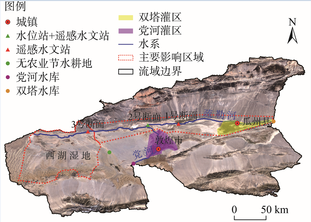
 ),杨胜天1,娄和震1(